Can I do this?
If you like to explore, can navigate by map and compass, and have enough strength and endurance to hike off-trail in rugged terrain for several hours, then you are ready to participate in a navigation race. You may be unsure about your map and compass skills, but don’t be discouraged. There are many entry-points to prepare yourself for a navigation race, including beginner-friendly local events and hands-on navigation clinics. And you’ll be rewarded with newfound skills and confidence to explore the backcountry and discover beautiful new sights that you never would have experienced before.
You can begin preparing for a navigation race by hiking or trail running to build strength and endurance in steep and rugged conditions. If you wish to take up trail running, start with some shorter Northwest Trail Runs events and slowly work your way up to longer distances. You can also seek group runs and training advice at local running shops such as Seven Hills Running Shop in the Magnolia neighborhood of Seattle or The Balanced Athlete in Renton.
If you wish to take up hiking, become a member of Washington Trails Association to learn about local hiking opportunities and best hiking practices. Join a MeetUp group to find hiking partners and carpools. You can even sign up for a trail work party to help repair hiking trails, which is not just a good thing to do, but also an excellent strength workout!
To get started in navigation, sign up for one of our Introduction to Navigation clinics. Our clinics include guided, hands-on practice courses, the most effective way for beginners to learn navigation. Additionally, Cascade Orienteering Club offers local orienteering events year-round. These events often include beginner and intermediate courses, as well as free beginner instruction. Start by attending events in simple and familiar venues such as college campuses or city parks, then slowly work your way up to attending events in increasingly challenging (forested, steep, varied) terrain. While COC uses more specialized maps of a different scale than MerGeo events, the skills you learn transfer well.
RECIPE TO BECOME A NAVIGATION RACER:
- 1 part hiking or trail running
- 1 part Navigation Clinic
- 2 parts COC orienteering meets
Combine for several weeks or months until confidence is gained.
A faster alternative is to team up with a friend who is more experienced and learn as you go.
Then register for a MerGeo Navigation Race and enjoy!
How it works
THE BASICS
Checkpoints are circled on a topographic map. Your goal is to find as many as you can within your chosen time limit, using only map, compass, and your wits! Common time limits are 4, 7, 8, 10, and 24 hours. You may participate solo in events as long as 7 hours, while events of 8 hours and more require that you have a teammate. Teams may be between 2 and 5 people in size.
PLANNING YOUR ROUTE
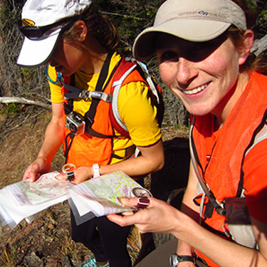
You will receive the map before the race start (typically at least an hour), so that you (and your team if you have one) may plan which checkpoints you wish to visit and the route you’ll take to get there. You can visit as many or as few checkpoints as you want, and in any order. Your team will need to stay together at all times. You can change your plan as you go along, but it’s very helpful to at least start with some kind of plan. Each team member may have their own map.
INTENTION SHEET
Once you’ve identified your plan, you must mark it on a second copy of the map, called the Intention Sheet, which you will turn in before the event begins. The Intention Sheet is a safety measure, to narrow down the area Search & Rescue teams would look for an injured or missing team. You are not obligated to stick to the route you’ve indicated on your Intention Sheet and there are other safety measures in place which will be discussed later in this article.
TIP!: Bring writing utensils to mark your route on your map! Highlighters are great for this.
POINT VALUES
When planning your route, remember that checkpoints have varying point values. All points are rounded down to the tens. For example, checkpoint 39 is worth 30 points, and checkpoint 103 is worth 100 points. Collect the most points to win!
CATEGORIES
There are many classes to compete in, separated by various combinations of age and gender, such as Veteran Women or Junior Men. The “Open” class is the competitive class, with no age restrictions. However, you don’t need to be competitive to enjoy navigation races, many racers participate at a casual hiking speed just for the joy of exploration!
THE PASSPORT
In addition to the map, you’ll also receive a passport (one per team), which is also referred to as a “punch card.” The passport is made of a durable, weather-resistant paper, and has rows of numbered boxes printed on it. When you arrive at a checkpoint, you will find an orange and white “orienteering flag” which resembles a sort of box kite. Attached to the flag is a number placard, indicating which checkpoint you have found, and also a unique pin hole puncher. Use the pin hole puncher to punch the corresponding box on your passport, to prove that you visited the checkpoint!
SIGN-IN SHEET
In addition to the flag and pin hole puncher, you’ll also find a clipboard with a sign-in sheet and pencil at each checkpoint. As a safety measure, all teams must write what time they arrived at the checkpoint, their team name or number, and what checkpoint number they intend to go to next. This practice helps narrow down the area that Search & Rescue would look for a team, should an emergency occur.
THE START
A few minutes before the start, the race director will give a pre-race briefing to review the rules and give notes on the terrain. The race clock does not begin until the race director counts down from 10 and shouts, “GO!!” and everyone goes hiking, running, and trotting in different directions!
IMPORTANT!: Map Handout does not designate the start of the event. Even if you quickly finish planning your route, you may not leave the start area until after the pre-race briefing and the race director shouts, “GO!!”
GO LONGER
If you’ve signed up for a shorter event (4 hours, for example), but decide mid-event that you’d like to explore more, you can decide mid-race to participate in one of the longer offerings instead (8 hours, for example). Please inform the results crew of the change when you return. Inversely, if you signed up for a longer event (8 hours, for example), but decide that you’ve had enough, you may also return earlier (at the 4-hour mark, for example).
AT THE FINISH
When you return, you will turn in your passport. It is important to be on time because you will lose points for each minute you are late! (Usually 10 points for every minute, or fraction of a minute, that you are late.)
TIP!: Leave some checkpoints near the start/finish for last, so that you are near the finish as the race clock runs out.
Now that you’re done, enjoy refreshments and share your routes and tales with fellow participants. Results are calculated at the event and are typically ready for an award ceremony 45 to 60 minutes after the finish. Prizes will be given out to those with the highest scores in different categories.
What to wear
The two most important items of nav race attire are:
- Something to cover your legs, particularly at the shins
- Comfortable footwear with good traction
There are many options for these two items, depending upon your own preferences, the speed at which you’ll move, and the nature of the terrain. Some like to wear hiking boots, pants, and gaiters, while others prefer trail running shoes, knickers, and tall soccer socks or lightweight orienteering gaiters, Your gear need not be fancy, as another feature that many nav racers sport are small tears and patches in their designated navigation clothes!
What to carry
Nav race participants must carry:
- Bottle or bladder able to carry at least 0.5 liters of water per team member, although you will likely want more capacity
- A whistle for signaling in case of emergency (three short blasts)
- A compass
- A light
- A watch (or other time-telling device)
- A writing utensil (pencil works best) to mark the checkpoint intention sheets
- Enough emergency blankets (mylar or tyvek wrap or similar) to provide emergency shelter for the entire team
Participants should also carry:
- Food
- Cell phone
- Additional water carrying capacity
- Clothing appropriate to the weather, accounting for the possibility of injury or exhaustion
- First aid kit, including blister treatment
- Extra batteries
How to plan a route
At a navigation race, maps are handed out typically an hour before the race clock begins. This gives participants time to decide which checkpoints to visit and plan a route between them. There are several aspects that introduce strategy to route planning:
- Checkpoints have varying point values (typically between 20 and 100 points)
- Checkpoints vary in navigational difficulty (near a road or remote, distinct or indistinct features)
- Checkpoints vary in physical difficulty (flat or steep, near or far)
- There is a time limit! (10 points lost for every minute, or fraction of a minute, that you’re late)
- Your own personal strengths and weaknesses (runner vs. navigator)
KNOW YOUR PACE
So how to begin? It starts with knowing your pace. Navigating and travelling off-trail in rugged terrain is considerably slower than walking on city streets or even hiking on a groomed trail. If you plan to hike during the nav race, 2-mph is a good place to start. Runners and experienced navigators might estimate 4-mph, while those doing a little bit of both running and hiking might average 3-mph.
THE DISTANCE YOU’LL TRAVEL
Now that you’ve selected a pace, multiply that by the number of hours you are competing. For example, in a 4-hour race, a 2-mph hiker might travel about 8 miles.
MAKE A STRING TO SCALE
Look up the scale of the competition map, then figure out how much length on the string represents a mile on that map. This is best done before an event, not on race morning. The easiest way to do this is to find an old map with the same scale. If you don’t have one, here’s an example of how to do the math:
- If a map is 1:30000 in scale, that means 1 of any unit on the map represents 30,000 of that unit on the ground.
- Miles are tricky, so let’s convert it into something metric. 1609 meters = approx. 1 mile
- 1609-m is the distance we want on the ground, so a 1/30000 fraction of that represents 1609-m on the map…
- Multiply 1609 meters by 1/30000 (this is the same thing as simply dividing 1609 by 30,000)
- The result is 0.0536333 meters, we’ll just round it down to 0.05
- 0.05-meters is 5 centimeters
- On a 1:30000 map, 5-cm on the map represents 1609m or 1 mile!
- Check your result by doing the math backwards: 5-cm (units on the map) x 30000 (units on the ground) = 150,000-cm on the ground… change centimeters to meters, that’s 1500-m, or nearly a mile! (109 meters were lost when we rounded down)
Once you’ve figured out how many centimeters represent a mile, mark a string for every “mile” for as many miles as you expect to travel. For example if you expect to travel 8 miles during the event, mark the string every 5-cm eight times. Now the distance you expect to travel is represented on a string!
HIGHLIGHT THE MAP
Bring some colored highlighters with you on race morning. Use these to color-code checkpoints and features on the map. For example, you might color code this way:
- Pink= highest point value checkpoints
- Orange= high point value checkpoints
- Blue = checkpoints that have water
- Yellow = your route
Now you can look at the map and more easily see a route that prioritizes high point values and includes a water stop.
LAY OUT THE STRING
With your map color-coded and string marked, begin your string at the start, then lay it across the map, connecting checkpoints that you wish to visit. Try to lay the string along an actual route you would take, turning with roads and going around cliffs. You don’t have to be exact, but you don’t want to measure a straight line between checkpoints unless you actually plan to walk in a straight line or have wings. Make sure that you have enough string to return to the finish.
Now add up the checkpoints that you’ve connected and note how many points it totals. Can you move the string a bit so that you skip a lower point control in order to reach a higher point control? Does your route include water? Now you are strategizing! Once you’ve identified a route you’re happy with, mark it on your map with a highlighter. You can simply draw a straight line between checkpoints, or highlight the actual route you plan to take, whichever you prefer.
Don’t take the string off the map yet! Next, note where the hour marks on your string are. Next to each hour mark, mark an hour on your map as a time estimate. So next to the first hour mark, write “1 hour,” next to the second hour mark, write “2 hours,” and so on. During the race, you can check your watch against your notes to see if you are on schedule. If you fall behind, you can skip some checkpoints on your route to get back on track.
Some other strategies to consider when choosing a route:
- Try to minimize gaining excess elevation. Don’t repeatedly go up and down contours when you can go along or around instead.
- Return to the finish early, then do a small loop from there to reduce your risk of being late.
- Identify a bail-out point. If you’re falling behind schedule, you can return straight to the finish from here.
- Make navigation to get to the finish fairly easy, such as along a road. You might be in a hurry!
- If there are any large barriers to travel, such as a limited number of bridges, note these on your map and plan around them.
- Look at the features the checkpoints are on. Does it look difficult to find? Are there distinct features that will help you find it? Consider skipping checkpoints that look too difficult for your skill level, unless you are feeling up to the challenge!
That’s it! You’ve planned a route for a nav race. After the event, you can learn even more by comparing your route with other competitors.